China Siwei Participates in Myanmar Earthquake Emergency Response
The satellite imaging company has joined the international response to the disaster.
Myanmar was hit by a magnitude 7.9 earthquake on March 29th, along with parts of India, Thailand, and China. At present 2,719 people have lost their lives, while 4,521 have been injured with 441 missing.
In response to the devastating earthquake, India, Indonesia, Malaysia, Singapore, Thailand, Vietnam, and China have sent emergency response teams to the country, along with aid from ASEAN1, the UAE, Cambodia, and Australia.
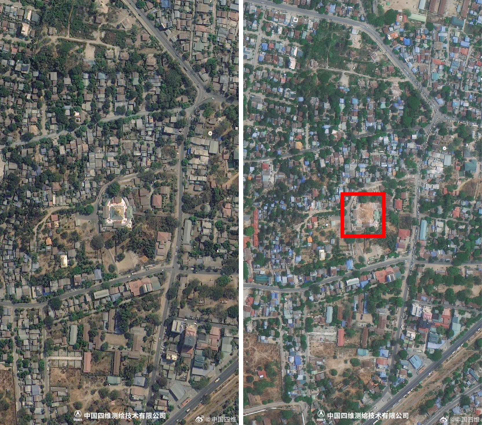
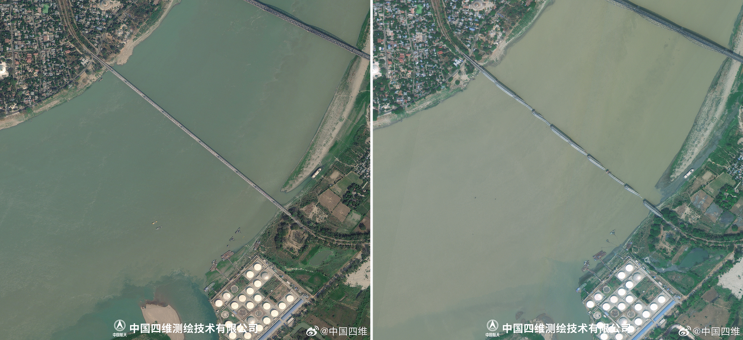
As part of the emergency response from China, China Siwei Survey and Mapping Technology (中国四维测绘技术有限公司) has provided imaging of effected areas to rescue teams. Additionally, China Siwei released some of the before and after images, along with the following statement (translated with subtitles added):
At 14:20 on March 28, 2025, the China Earthquake Networks Center determined that a 7.9-magnitude earthquake occurred in Myanmar (21.85°N, 95.95°E) at a depth of 30 kilometers.
On the evening of March 29, the Myanmar National Administrative Council announced that as of now, the death toll in disaster-affected areas nationwide has reached 1,644, with 3,408 injured and 139 missing. It was also announced that, at the request of the Myanmar government, the Chinese government dispatched a Chinese rescue team, which arrived in Myanmar on the afternoon of March 29 local time to carry out international rescue operations.
On March 31, Myanmar's Department of Meteorology and Hydrology released a report stating that as of the morning of the 31st, a total of 36 aftershocks had occurred following the strong earthquake on March 28, with magnitudes ranging from 2.8 to 7.5.
China Siwei's Emergency Response
After the earthquake, China Siwei immediately activated its emergency response mechanism, utilizing its new-generation commercial remote sensing satellite system to urgently deploy multiple satellites for emergency imaging. These satellites surveyed the disaster-stricken areas and surrounding affected regions, quickly obtaining satellite imagery of the disaster zone. The relevant images have been submitted to the appropriate authorities and the International Charter on Space and Major Disasters to support earthquake relief efforts. This provides crucial assistance for cross-border life-saving operations and serves as an important reference for post-disaster assessment and reconstruction planning.
By comparing pre-earthquake images taken by the Siwei Gaijing-3 01 satellite on March 9 with post-earthquake images captured by Siwei Gaijing-3 01, Siwei Gaijing-1 01, Gaofen Multi-Mode satellites, and others on March 28, 29, and 30, it was observed that many buildings in Myanmar sustained varying degrees of damage, with multiple high-rise buildings collapsing.
The Siwei Gaijing-2 03 and 04 satellites, which are radar satellites, were able to capture images of the disaster area regardless of weather and lighting conditions. Despite complex post-earthquake weather conditions, these satellites utilized microwave imaging to penetrate clouds and haze, enabling all-weather, round-the-clock observation of the disaster area. This helped rapidly assess the extent of disaster damage.
Within 48 hours after the earthquake, time-series radar images from Siwei Gaijing-2 03 revealed that bridges in Mandalay were fractured and some buildings were at risk of collapse.
During the monitoring of this Myanmar earthquake, China Siwei’s next-generation commercial remote sensing satellite system also captured satellite images of China’s border regions, providing important support for disaster monitoring and early warning in areas that felt the earthquake strongly.
Ongoing Monitoring and Support
Moving forward, China Siwei will continue to monitor the disaster area using its new-generation commercial remote sensing satellite system, contributing to earthquake relief efforts through satellite remote sensing technology. This effort aims to provide precise spatiotemporal information to support global disaster prevention, mitigation, and sustainable development.
If there are any problems with this translation please reach out and correct me. More images from China Siwei are available here.
The Association of Southeast Asian Nations, abbreviated as ASEAN. Member states of the group are Brunei, Cambodia, Indonesia, Laos, Malaysia, Myanmar, the Philippines, Singapore, Thailand, and Vietnam.


